14 th SCOPE-CM Executive Panel meeting

Link to the 14th SEP meeting (Feb 2019).
Link to the 13th SEP meeting (Sep 2018).
Link to the 12th SEP meeting (Oct 2017).
Link to the 11th SEP meeting 2016 (Sep 2016).
Background
SCOPE-CM (“Sustained and COordinated Processing of Environmental satellite data for Climate Monitoring”) is a network of agencies and operators of environmental satellite systems and interfaces with WMO, WCRP, GCOS, CGMS, CEOS and GEO. It offers its support to coordinate and facilitate international activities to generate Climate Data Records (CDR) from multi-agency satellite data. Within SCOPE-CM, the contributing organisations coordinate their scientific and technical development activities and cooperate on the basis of shared and distributed responsibilities for the generation of global products.
The SCOPE-CM Network was established in November 2008 with the approval of the first Implementation Plan. The initial participating organisations include the operators of operational satellites: CMA (China Meteorological Administration), EUMETSAT (European Organisation for Meteorological Satellites), JMA (Japan Meteorological Agency), and NOAA (National Oceanic and Atmospheric Administration, USA).
In the first phase 2008-2012 five pilot projects were conducted in order to establish partnership and perform coordinated activities within SCOPE-CM. The achievements of these pilot projects include inter alia the coherent and coordinated implementation of a single retrieval algorithm at different satellite processing chains (geostationary surface albedo), the systematic inter-comparison of different approaches to derive cloud properties from the 30 years AVHRR data record.
The second phase of SCOPE-CM was kicked off in 2012 with the approval of an updated Implementation Plan. This plan is aiming at establishing a systematic approach to increase the maturity of CDR generation capabilities as well as to enhanced the existing and to create new structures for its sustainable generation.
Dedicated SCOPE-CM Projects are conducted by international consortia and aim to bring specific CDR capabilities to a higher maturity level.
The main focus is on CDR capabilities that explicitly benefit from multi-national and inter-organisational coordination and cooperation among the participating organisations and agencies.
http://www.wmo.int/pages/prog/sat/scope-cm_en.php
Conceptual framework
The figure below illustrates the concept framework of SCOPE-CM project.
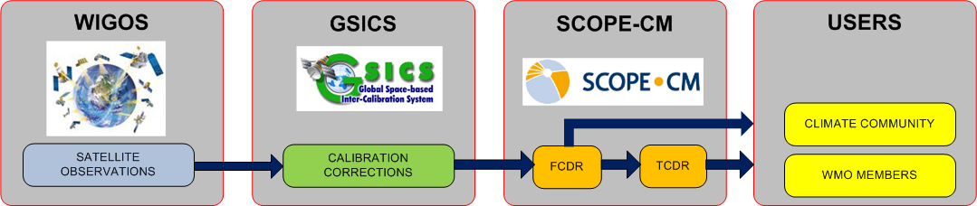
A Fundamental Climate Data Record (FCDR) can be defined as a well-characterised, long term data record, usually involving a series of instruments, with potentially changing measurement approach, but with overlaps and calibrations sufficient to allow the generation of products that are accurate an stable, both in space and time, to support climate applications e.g calibrated radiances, backscatter of active instruments, or radio occultation bending angles. FCDR also include the ancillary data used to calibrate them. An essaentiel Climate Variable (ECV) is a geographical variable that is associated with climate variation and change as well as the impact of climate change onto Earth.