Land surface albedo from geostationary satellites (LAGS)
This projects concerns land surface albedo retrieval. The geostationary surface albedo (GSA) algorithm, jointly developed at EUMETSAT and JRC, has been proposed for the generation of this dataset. GSA can ingest imagery acquired by five geostationary satellites—Geostationary Operational Environmental Satellite (GOES): two orbits over the American continents/Pacific region, Meteosat: two orbits over Europe/Africa and the Indian Ocean, GMS: one orbit over East Asia and Oceania—to retrieve land surface albedo for the entire Earth, except for the poles.
The project aims at the usage of unify the calibration method, re-analysis data (from ECMWF) and cloud screening approach in order to generate space and time homogeneous dataset.
A background and overview on LAGS is presented in this paper:
Lattanzio, A.; Schulz, J.; Matthews, J.; Okuyama, A.; Theodore, B.; Bates, J.J.; Knapp, K.R.; Kosaka, Y.; Schüller, L. Land Surface Albedo from Geostationary Satelites: A Multiagency Collaboration within SCOPE-CM. Bull. Amer. Meteorol. Soc 2013, 94, 205–214. DOI: http://dx.doi.org/10.1175/BAMS-D-11-00230.1
Project leader: A. Lattanzio, EUMETSAT, Germany (alessio.lattanzio@eumetsat.int)
Project Team:
EUMETSAT; A. Lattanzio (project leader)
NOAA: J. Matthews
JMA: Hiroshi Suzue (M. Takahashi)
MeteoSwiss (CMSAF): Anke Duguay-Tetzlaff and Quentin Bourgeois
KMA/NMSC: Eunha Sohn and Soobong Lee
Project SCM-03 description
The details about the cloud mask scheme used can be found in the following web page:
Poster presented at the EGU 2013
Poster presented at the Climate Symposium 2014
Poster presented at the AMS Conference 2015
Poster presented at the QA4ECV Review Meeting 2015
Poster presented at the EGU 2015
Validation
ALBEDOVAL: Meteosat First Generation (1982-2010): the analysis focused mainly on four aspects: assessment of the uncertainties, temporal consistency, validation against in-situ measurements and inter-comparison with other satellite products.
ALBEDOVAL2: Meteosat First Generation (1982-2010): Generation of an online selection of validation sites. An assessment of the MSA-retrieved anisotropy characterisation. Assessment of retrieval over snow. A comparison with the AVHRR-based GLASS surface albedo has been performed for the pre-MODIS era prior to the year 2000.
Lattanzio, A., Fell, F., Bennartz, R., Trigo, I. F., and Schulz, J.: Quality assessment and improvement of the EUMETSAT Meteosat Surface Albedo Climate Data Record, Atmos. Meas. Tech., 8, 4561-4571, DOI: http://dx.doi.org/10.5194/amt-8-4561-2015
Surface Albedo Validation Sites (SAVS): it provides a comprehensive inventory of more than 2000 potential surface albedo validation sites.
Loew, A., Bennartz, R., Fell, F., Lattanzio, A., Doutriaux-Boucher, M., and Schulz, J.: A database of global reference sites to support validation of satellite surface albedo datasets (SAVS 1.0), Earth Syst. Sci. Data Discuss. DOI: http://dx.doi.org/doi:10.5194/essd-2016-11
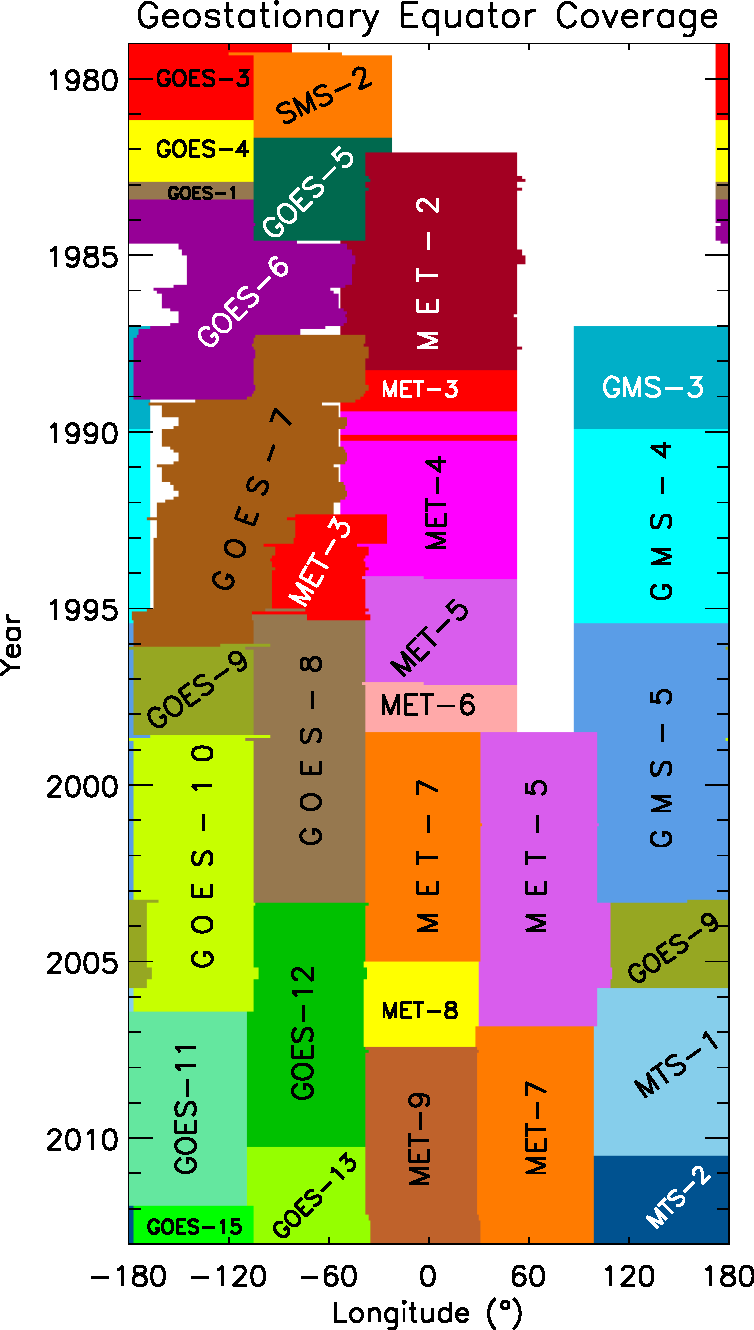
Left panel: Spatial coverage achievable using a ring of Geostationary satellites. The limit in latitude is around 65 degrees both north and south hemisphere. Right panel: Temporal coverage achievable exploiting Geostationary satellites from EUMETSAT, NOAA and JMA. Apart from a small gap around 60 degrees longitudes, the coverage is spanning from the 1980s to the present.
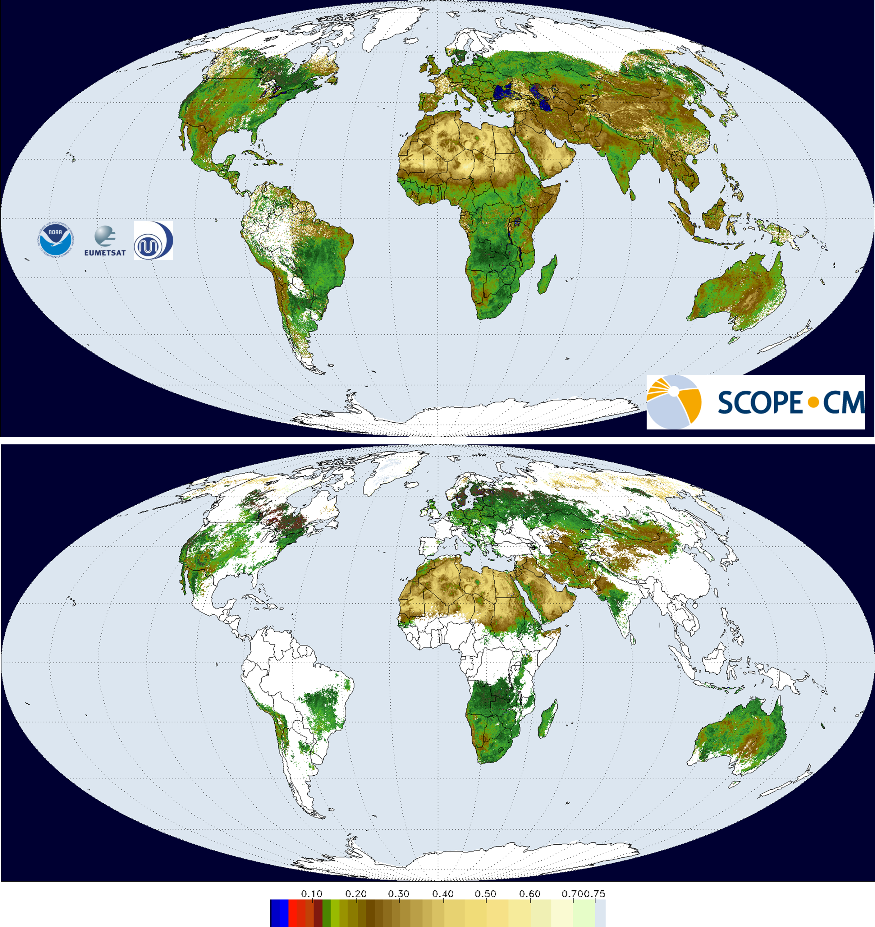
Top panel: GSA black sky albedo spatial composite (0.25° resolution) product proof of concept for the period 1-10 May 2001. The albedo estimated in the satellite sensor spectral response is converted into a broadband (0.3-3.0 mm) value. The albedo values are averaged in overlapping areas using the estimated retrieval error as weight. White regions are incomplete coverage due to sampling or cloudiness. Bottom panel: MODIS Black sky albedo (MCD43C3) for the period 1-16 May 2001 (0.05° spatial resolution, broadband 0.3-5.0 mm). In this map at least 75% of the albedo values are estimated through a full inversion and for a maximum of 25% information is used from an archetypal Bidirectional Reflectance Distribution Function (BRDF) database